Ferry Sb

Haz clic para cargar el mapa interactivo
Lista de paradas
      Mapa

      East 34th Street – Gov. Island/Yankee Pier

      East 34th Street

      06:3307:1808:0308:4809:3310:1811:0611:5412:4213:5114:4115:2916:1717:0517:5418:4319:3220:2120:58

      Corlears Hook

      06:4507:3008:1509:0009:4510:3011:1812:0612:5414:0314:5315:4116:2917:1718:0618:5519:4420:3321:10

      Wall St/Pier 11

      06:5407:3908:2409:0909:5410:4111:2912:1713:0514:1415:0415:5216:4017:2818:1719:0619:5520:4421:21

      Atlantic Ave/BBP Pier 6

      07:0107:4608:3109:1610:0110:4811:3612:2413:1214:2115:1115:5916:4717:3518:2419:1320:0220:5121:28

      Red Hook/Atlantic Basin

      07:0907:5408:3909:2410:0910:5611:4412:3213:2014:2915:1916:0716:5517:4318:2919:1820:0720:5621:33

      Gov. Island/Yankee Pier

      07:1307:5808:4309:2810:1311:0011:4812:3613:2414:3315:2316:1116:5917:47
      Times marked with "—" indicate that the vehicle does not stop at this stop.

      Gov. Island/Yankee Pier – East 34th Street

      Gov. Island/Yankee Pier07:1808:0308:4809:3310:1811:0511:5313:0313:5314:3815:2816:1617:0517:53
      Red Hook/Atlantic Basin06:4007:2508:1008:5509:4010:2511:1212:0013:1014:0014:4515:3516:2317:1318:0118:4019:2920:1721:06
      Atlantic Ave/BBP Pier 606:4807:3308:1809:0309:4810:3311:2112:0913:1914:0914:5415:4416:3217:2218:1018:4919:3820:2621:15
      Wall St/Pier 1106:5607:4108:2609:1109:5610:4111:3012:1813:2814:1815:0315:5316:4117:3118:1918:5819:4720:3521:24
      Corlears Hook07:0307:4808:3309:1810:0310:4811:3812:2613:3614:2615:1116:0116:4917:3918:2719:0619:5520:4321:32
      East 34th Street07:1207:5708:4209:2710:1210:5711:4712:3513:4514:3515:2016:1016:5817:4818:3619:1520:0420:5221:41
      Times marked with "—" indicate that the vehicle does not stop at this stop.
      Times marked with "—" indicate that the vehicle does not stop at this stop.
      Integra salidas en tiempo real en tu aplicación Acceso gratuito a la API →

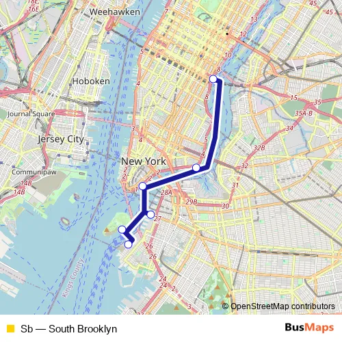
      Route Path (Streets & Roads)

      Ida: East 34th Street – Gov. Island/Yankee Pier
      FDR Drive - Bridge Park Drive - King Street
      Vuelta: Gov. Island/Yankee Pier – East 34th Street
      King Street - Bridge Park Drive - FDR Drive

      Schedules and stops for this route are published in GTFS: nyc-ferry

      Ferry Sb FAQ

      • What time does the Sb ferry start operating?

        Services on the Sb - South Brooklyn ferry start at 06:33 on lunes, martes, miércoles, jueves, viernes, sábado, domingo.

      • What time does the Sb ferry stop working?

        Services on the Sb - South Brooklyn ferry stop at 21:33 on lunes, martes, miércoles, jueves, viernes, sábado, domingo.

      • Is there a Sb ferry stop near me?

        Click here to view the nearest Sb - South Brooklyn ferry stop.

      NYC Ferry Sb ferry Route Map

      Sb ferry Line Map PDF Version: Sb timetable, stops and map

      Sb (Brooklyn Ferries)

      The first stop of the Sb ferry route is East 34th Street and the last stop is Gov. Island/Yankee Pier. Sb (South Brooklyn) is operational during todos los días.

      Additional information: Sb has 6 stops and the total trip duration for this route is approximately 42 minutes.

      See why over 2 million users trust and consider busmaps.com as the best public transport website. busmaps gives you Brooklyn Ferries suggested routes, real-time bus tracker, line route maps in Brooklyn, and helps to find the closest Sb ferry stops near you. No internet available? Download an offline PDF map and bus schedule for the Sb ferry to take on your trip.

      Sb ferry near me

      Last updated on 8 de mayo de 2026